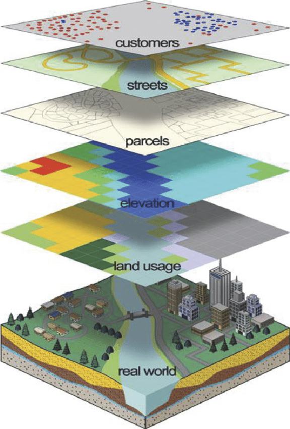
Geographic Information Systems (GIS)
We have huge experience with complex data sets in the GIS related field, as well as in storm water management, environmental systems, and health research. In all of these areas, our Geographic Information System (GIS) specialists and software engineers design and implement custom solutions for collecting, processing, analyzing and R & D reporting on system information.
Our expertise in ESRI software, design, and deployments come from working with the technology on a daily basis. We maintain and run our own ArcGIS server infrastructure which has to have high availability to support our clients.
Geocortex Essentials provides a framework to easily administer and configure rich web mapping and web GIS viewers. Geocortex software transforms how organization design, develop and maintain ESRI web-based applications by enabling them to do more; faster, for less cost and risk and with better results.
We built a proprietary 3D mapping engine to take GIS visualization and decision making to the next level. Our 3D engine offers a unique differentiator in supporting 3D data integration, 3D GIS application and enabling AR/VR/MR visualization of terrain & 3D objects.
- ESRI Deployment
- Geocortex Deployment
- AM/FM Utility Mapping
- 3D GIS & Analytics
- Municipal GIS
- Mining
- Landbase Mapping
- Topographic Mapping Services
- Contour Maps
- Survey & Data Collection
- Photogrammetry
- Engineering Services
Our Portfolio
GIS based workflow management System
Development of generic workflow framework to configure for any department and integrate with Web based GIS application to initiate projects, monitor, measure KPIs and close projects as necessary.
7 department's business processes are completely automated with workflow. Designed and developed applications to monitor projects, schemes implemented.
Water Management System with IOT & GIS
Operational Dashboard with real-time monitoring of water level, quality parameters from sensors installed in all locations Generate alerts and events when water quality parameters not within threshold values Mobile GIS application to navigate to the asset location, record incident and view all incidents in Dashboard application Integration of Enterprise Asset Management (EAM), SCADA and IOT gateways to visualize operational equipment efficiency (OEE) on GIS map.
Port vehicles Real-time monitoring in 3D GIS
Real-time monitoring of containers as well as yard vehicles (internal trucks, Reach Stackers, Straddle carriers, Quay cranes, RTG, Forklift, ECH.) on 3D GIS map.
Integration live video feed to visualize vehicle movements along with 3D GIS map.
Call Truck/vehicle operators from central command center.
Improve vehicles operational efficiency by monitoring of ETA, current job, speed, container & Bay target location.
Locate vehicle based on vehicle ID and view all job details Geo-fence alerts.
Vegetation
Web and mobile mapping solution with online mapping for mobile and tablets, providing integrated Geospatial Information for treescape field workers.
Key feature of solution
► View assets on map with all information
► View history on each asset by clicking on the asset icon
► View Tree species on each asset by clicking on the asset icon
► Search for an asset
► Capture new asset by GPS and form fields
► Integrate forms
► Automated Notifications
► Signature capture on the forms
► Report generation (CSV and charts)
► Tree icon for data
► Capture Photos
Aerial Data Acquisition
Aerial Mapping has designed aerial data acquisition plans for many of projects. These flight designs include missions using precision film cameras, digital imaging sensors, unmanned aerial systems (UAS or drones) and various LiDAR systems.
3D Urban Planner
Urban Planning for Sustainable Growth
Load 2D GIS data to generate 3D building mass models or load 3D BIM in GLTF/IFC formats to visualize 3D buildings and simulate scenarios to do impact analysis on environment, energy demand, water demand etc. for sustainable growth of cities
Solution helps Urban Planners to simulate various what-if scenarios in increasing floors, change space usage type etc. and compare results for better decision making prior to initiating the project.
Analytical Models
Application has 20+ Urban Analytical models based on GIS data, socio economic data and environment to estimate the current future needs of building, block, town and city and its impact on environment.